Snow babies, seals, and maniacal Arctic travelers: A visit to Eagle Island

Adventurer Josephine D Peary lived on Eagle Island for more than 50 summers.

Adventurer-author-mother-wife Josephine D. Peary lived on Casco Bay’s Eagle Island for more than 50 summers.  (Photo from Josephine Diebitsch Peary Collection, Maine Women Writers Collection, University of New England, Portland, Maine).

Even maniacal travelers need a respite once in a while, if only to plan their next adventures.  Eagle Island, in Maine’s Casco Bay, was such a haven for big adventurers Admiral Robert and Josephine Peary.

Admiral Peary, as many know, was credited with being the first person, along with Matthew Henson and other expedition members, to reach the North Pole on April 6, 1909.

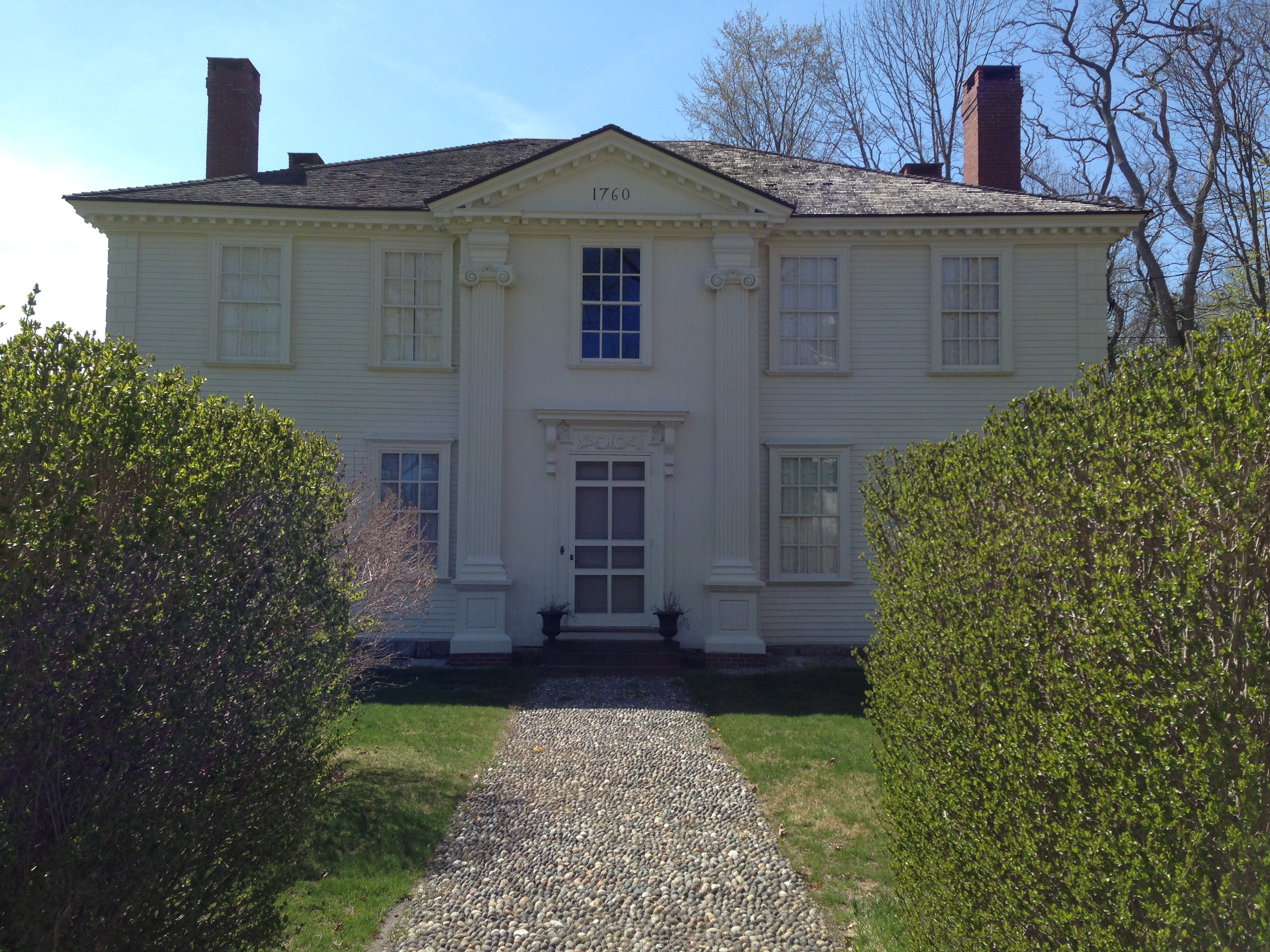
Long before reaching the Pole, however, Peary set sail for Eagle Island, which he bought for $100 in 1877, just a few years after graduating from Bowdoin College. There, in the early 1900s, the Pearys built a two-room cottage that eventually evolved into a larger home (but not a mansion).  The family spent many summers on the island, which is now a State Historic Site.

In the 1890s, Admiral Peary often was in the news, celebrated (and sometimes maligned) as the great explorer. I do like his motto, “Find a way, or make one” (Inveniam viam aut faciam). But Josephine is my hero, living proof that female maniacal travelers are not a recent phenomenon but have always existed.

Josephine's 19ss memoir described her first year in Greenland, from June of 1891 to August of 1892, when she explored northern Greenland with her husband and his expedition.

Josephine’s 1893 memoir described her first year in Greenland (June, 1891 to August, 1892).

Three years into her marriage, Josephine bucked popular criticism to travel with her husband on his first trip to Greenland.  There, living in a cobbled-together house with Peary and five other men, Josephine threw herself into Arctic living:  She explored, trapped, hunted, cooked, tanned skins, and created outfits from fur and feature.  She also nursed her husband, who had shattered his leg en route to Greenland.  Later, Josephine chronicled her adventures in her first book, An Arctic Journal.

On her next stay in Greenland, in 1893, Josephine gave birth to her daughter Marie, soon-dubbed the “Snow Baby” by the Inuit locals and the international press. I have yet to find an account of Marie’s birth, but I  imagine that Josephine labored in that cobbled-together shack, probably with with no midwife nearby (although it’s likely that the expedition included a doctor with some basic obstetrical training).

Snow Baby Marie Peary.

Snow Baby Marie Peary (Library of Congress photo).

Of course, Inuit women had been having babies in the Arctic for centuries. However, childbirth remained a dangerous affair in 1893,  and even more terrifying when you didn’t know what to expect because you were living in an isolated foreign land.  For Josephine, however, it almost seems as if Marie’s birth was a blessed non-event, just something she did between prepping furs and cooking ptarmigan stew. She later wrote a book about Marie’s first years, The Snow Baby (1901).

All told, Josephine made a half-dozen trips to the Arctic, including one miserable winter spent, with young Marie, on board the Windward, a ship that had become bound in the ice (although not far from shore), in 1901.  There, Josephine met llakasingwah, Peary’s pregnant Inuit mistress.  Some sources report that Ilakasingwah also was living on board the ship (although that’s not certain).  Peary himself was 300 miles away, at a winter camp in Fort Conger.  It must have been an especially chilly winter for Josephine.

Back on Eagle Island, Josephine presided over what her son later called the island’s most “momentous event,” the September day in  1909 when the South Harpswell postmaster arrived with a telegram from Peary announcing that he had reached the Pole.  Soon a small group of reporters gathered on the island.  One reportedly said, “What do you have to say now, Mrs. Peary?”

In what I think of as true Josephine fashion, Mrs. Peary said to the group, “”I say come on boys, let’s have a drink.”

Admiral Peary, on his porch, looking out towards Harpswell Neck, a short boat ride away.

Admiral Peary, on his porch, looking out towards Harpswell Neck, a short boat ride away.

Eagle Island is located about 6 miles from Portland and about 1.5 miles from the end of Harpswell Neck. I visited with my Seal (my son), on Atlantic Seal Cruises, out of South Freeport harbor.  The island is a wonderful destination for a summer afternoon. For travelers like me who don’t own a boat, getting there requires some advance planning (see info below), but it’s a trip worth making.  The seals en route are a bonus.

First, the island offers incredible views, peaceful walking paths, and that sense of freedom I always feel  when visiting a Maine island. 

And then there is the Peary home, full of quirky Arctic artifacts and family memorabilia.  Narwhal tusks.  Various stuffed birds.  Photos of angora rabbits from the era when one family member tried to make a go of an island rabbit farm.

Peary designed his home to reflect the lines of a ship, with the library and front porch creating the illusion of a ship's prow/

Peary designed his home to reflect the lines of a ship, with the front porch creating an illusion of a ship’s pilot house. On the second floor of the house, from certain windows, the ocean seems so close that visitors almost feel as if they are on board a ship.

But what I like most about Eagle Island is  that Josephine lived there, spending more than 50 summers on the island, from 1904 until her death in 1955. (Admiral Peary died much earlier, in 1920, of pernicious anemia).  Ultimately, Eagle Island became more Josephine’s place than her husband’s.

On the island, Josephine read and wrote and rowed and entertained.  She picked berries with her grandchildren and taught them how to tie their shoes. During the winters, she lived quietly in a home on Baxter Boulevard in Portland. By the end of her life, she was known more as Grandma than as the intrepid young woman who dared to travel to the far North.

Visitors are encouraged to play Peary family's player piano, which is operated via a set of foot pedals.

Visitors to Eagle Island are encouraged to play Peary family’s player piano, operated via a set of foot pedals.

In 1955, just a few months before Josephine’s death at age 92, the National Geographic Society awarded her its highest honor, the Medal of Achievement.

I imagine it was gratifying, to finally be recognized.  On the other hand, I also imagine Josephine shrugging off the honor as “just a little medal.”  Nice to have, but not nearly so great as hiking across Greenland’s tundra, or sitting on the porch at Eagle Island, looking out at the blue expanse of Casco Bay.

Sources and Resources

The Friends of Eagle Island have established a website, Peary’s Eagle Island, that provides information about the Pearys and the Island, as well as details on how to get there.  Marie L Cruises out of the Dolphin Marina in South Harpswell also offers regularly scheduled excursions to the island.

Josephine’s books are available online (see links above) but also have been reissued in print.

Josephine’s papers and photographs can be found at the University of New England in The Maine Women Writer’s  Collection.

For additional information about Josephine, see Patricia Erikson’s articles, with several links gathered together in one place at her blog, Heritage in Maine.

HensonAfrican-American Matthew Henson wrote a memoir about his dash to the Pole with Peary, A Negro Explorer at the  North Pole (1912).  Many books have been written about Henson, but a revised version of his memoir recently published is Matthew A. Henson’s Historic Arctic Journey: The Classic Account of One of the World’s Greatest Black Explorers (2009).

Finally, I’m well aware that Peary’s claim to have reach the North Pole is disputed by many, although I didn’t get into the details above as my focus here is Josephine.  For more on the controversy, see John Tierney’s New York Times column,  “Who was first at the North Pole?”

If Eagle Island intrigues you, you might also check out the Peary-MacMillan Arctic Museum on the campus of Bowdoin College in Brunswick, Maine.  See the Josephine D. Peary biography page for more info on Josephine.


Globalization, circa 1807, curses the Lady Pepperrell House

The Lady Pepperrell House, apparently released from its curse, on a recent spring afternoon.

The Lady Pepperrell House, apparently released from its curse, on a recent spring afternoon.

Lady Mary Hirst Pepperrell had impeccable taste.  So say many sources, but the best indicator is the home  she built in 1760 on Route 103 in Kittery Point.

The Lady Pepperrell House is one of Maine’s outstanding examples of 18th century Georgian-era architecture.  Its simple clean lines, graceful ionic pilasters, and large windows that flood the home with light invite house envy today.  But by the mid-19th century, many said the luxurious house was cursed.

It certainly looked cursed. Writing in the 1870s, historian Samuel Adams Drake described the house as “a somber old mansion, having, in despite of some relics of a former splendor, an unmistakable air of neglect and decay.  The massive entrance door hung by a single fastening, the fluted pilasters on either side were rotting away, window panes were shattered, chimney tops in ruins, the fences prostrate. It was nothing but a wreck ashore.  This was the house built by Lady Pepperell, after the death of Sir William.  Report said it was haunted; indeed I found it so, and by a living phantom.”

Lady Pepperrell’s house, built for her after the death of her husband Sir William, had almost become a metaphor for downfall of the Pepperrell family, except that the home’s decline began many years after the Pepperrell family’s Revolutionary War misfortune.

Besides, Loyalist William (Sparhawk) Pepperrell (who I’ve written about in another post) might have lost his property and most of what he held dear, but he lived a purposeful life in England after the war and ushered his four children successfully into adulthood.  The Lady, his grandmother, lived peacefully in her house, with no curse ever in evidence, until her death in 1789.

Such was not the case for the branch of the Cutts family that purchased Lady Pepperrell’s home in 1800 from Catherine and Daniel Humphreys, who had acquired it from Elizabeth Sparhawk (who was Catherine’s grandmother and Lady Pepperrell’s daughter).

In the 18th century, the Cutts clan, whose ancestors were among the first settlers of Kittery, established itself as one of the leading families of Kittery and Portsmouth. By 1800, Joseph Cutts was a captain and merchant wealthy enough to buy the elegant home, keeping it in the family, more or less. (Cutts was a descendent, via his mother, of the original William Pepperrell family).

But on the other side of the ocean, troubles stirred by the rise of Napoleon set in a motion a chain of events that led to the chaining of Charles Cutts, the Captain’s son, in an upstairs chamber.  He suffered from mental illness and reportedly was often chained to the floor to prevent injury to himself or others.

Drawing of Joseph Cutts (the Captain, I think, and not his son), attributed to Albert W. Fiske (Portsmouth Athenaeum collection).

Drawing of Joseph Cutts (the Captain, I think, and not his son), attributed to Albert W. Fiske (Portsmouth Athenaeum collection).

The Captain himself lost his sanity, although he lived a long life, dying at age 97 in 1861.  In 1839, another son, naval officer Joseph Cutts, killed himself in what once had been Lady Pepperrell’s bedchamber.  His death might have been the culminating blow for his sister, Sarah “Sally” Chauncey Cutts, caretaker to her father and brothers.  She too developed mental illness.

The key event in the demise of the Cutts family was Thomas Jefferson’s Embargo Act, passed in 1807 in a misguided attempt to stop British and French ships from seizing American vessels and to stop the British from impressing American merchant sailors into military service.  The Act banned all trade with Britain and France, both of which were the new nation’s biggest trading partners.

With the bill’s passage, Captain Cutts lost his livelihood. He could neither buy nor sell. His ships rotted in an anchorage behind Gerrish Island. By 1813, he was bankrupt and indebted to the government for unpaid duties.  (Some sources say the house was seized by the government for non-payment of taxes, and later redeemed by either Sally or another relative in the extended Cutts family). Although it’s likely that a genetics  played a large role in the family’s mental illness, the strain of losing his fortune probably contributed to Captain Cutts’s breakdown.

Drawing of Sally Cutts attributed to artist Albert W. Fiske (Portsmouth Atheneum Collection)

Drawing of Sally Cutts attributed to artist Albert W. Fiske (Portsmouth Athenaeum Collection)

On his undated mid-19th century visit, historian Drake described Sally as “a harmless maniac,” who was “the sole inhabitant of the old house; she and it were fallen into hopeless ruin together.” Her appearance, he wrote, “was weird and witch-like, and betokened squalid poverty. An old calash almost concealed her features from observation, except when she raised her head and glanced at us in a scared, furtive sort of way.”

She invited Drake and his companion into the house.  “Fragment of the original paper, representing ancient ruins, had peeled off the walls,” he wrote,  “and vandal hands had wrenched away the the pictured tiles from the fire-places. The upper rooms were but a repetition of the disorder and misery below stairs.

Sally led Drake and his companion to an upstairs “apartment,” where she “relapsed into imbecility, and seemed little conscious of our presence.”  In her room, “some antiquated furniture, doubtless family heirlooms, a small stove, and a bed, constituted all her worldly goods,” wrote Drake. “As she crooned over a scanty fire of two or three wet sticks, muttering to herself, and striving to warm her weathered hands, I thought I beheld in her the impersonation of Want and Despair.

I am a little skeptical as to whether or not Drake visited Sally Cutts in the Pepperrell House.  She died in 1874, (a year before Drake’s book was published) and spent time prior to her death living with friends who had taken her in.  Another writer, James H. Head, wrote of a similar visit to Sally Cutts in November of 1864, with his account published in the Boston Journal.  Sarah Orne Jewett presented a barely fictionalized account of a visit with “Miss Sally Chauncey” in Deephaven: Selected Stories and Sketches (1877), so presumably she visited her as well.

Captain Cutts and his family are buried in the Old Burying Ground across the street from his one-time home and the Congregational Church. A table-like memorial stone tells his story. (As you enter the cemetery, look to your left to see the Cutts memorial).

Captain Cutts and his family are buried in the Old Burying Ground across the street from his one-time home and the Congregational Church. A table-like memorial stone tells his story. (Entering via the cemetery’s maine gate, the Cutts memorial is readily visible, to the left).

Did poor Sally regularly open her door to touring writers who wanted to invade her privacy?  Or did Drake build upon and embellish the accounts of Head and Jewett? And am I the latest in a series of writers fascinated by the Cutts family history, even if it is a history that they would have preferred to keep private?

The story of the Cutts family, however, is worth remembering, because their family history is a microcosm for the economic devastation that Jefferson’s Embargo wreaked in the Seacoast region. Their pain helps us to better understand how the region suffered during this period of economic collapse.  Ships rotted in harbors. Many merchants declared bankruptcy. A ripple effect reverberated throughout the local economy. Portsmouth, once a thriving port, became a backwater instead of a rival to Boston or New York.

The Embargo Act inadvertently paved the way for the Seacoast region to become what it is today: historically rich, but economically underdeveloped compared to what it might have become.  The Seacoast region is not Boston, with its packed roadways and paved landscapes.

The losses suffered by the Cutts family and many others during the Embargo era have become our gain, in that we live in  what is now an economically vibrant but beautiful and sustainable community.  The story of the Cuttses connects with our story today.

A fire ravaged the Lady Pepperrell House on December 27, 1945 and caused extensive damage.  The home was restored by X and Y.  Portsmouth Herald photo from Historic New England digital collections.

Another sign of the curse? A fire ravaged the Lady Pepperrell House on December 27, 1945 and caused interior damage. John Fellows of Kittery oversaw the restoration. Historic New England (formerly the Society for the Preservation of New England Antiquities) owned the home from the 1940s until the 1980s, when the organization sold the home to a private owner. Portsmouth Herald photo from Historic New England digital collections.

The Lady Pepperrell House is protected by a preservation easement administered by Historic New England.  Other Kittery landmarks, however, such as the Pepperrell Mansion and the Bray House, are not protected. Although both homes are listed on the National Register of Historic Places, and currently are owned by good stewards, they could be torn down tomorrow if a property owner wanted to take that path.

These architectural artifacts of history remind us that we are not historical islands, despite our high tech gadgets and way of life. We live in both a global economy and an historical ecosystem where the past reverberates into the present.

Embargoes and lost fortunes lead to economic decline, paving the way for resurrection and reclamation.  Trolleys connect the city to the country, and bridges and automobiles (as I’ve written about here) swiftly change a way of life.  A grange hall becomes The Dance Hall, and a building where the Masons gathered transforms to a collection of gathering places for locals and visitors discovering the pleasures of walking across bridges.

Beware of curses– but only when we forget them.  In remembering Sally Cuts and her family, perhaps we’ll take more care as we construct our own story.

Lady Pepperrell House, undated photo (Historic New England Collection).

Lady Pepperrell House, undated photo (Historic New England Collection).

Resources and sources

For a great example of connecting the past to the present, read about Stories from The Grange and Kittery’s Foreside, a project organized by Drika Overton of The Dance Hall.

For more information the architectural details of the Lady Pepperrell House, see “Palladian Perfection, New England Style, Part 2: The Lady Pepperell House at Kittery Point Maine” at The Down East Dilettante.

To read more about Drake’s visit, see Chapter 10, “At Kittery Point, Maine,” in Nooks and Corners of the New England Coast, by Samuel Adams Drake (1875).

James Head’s Boston Journal account of his 1864 visit to Sally Cutts can be found in the Pepperrell House vertical file at the Portsmouth Athenaeum.

For some detailed photos of the exterior and interior of Lady Pepperrell’s house, see Donna Seger’s “Lady Pepperrell and Her House” at Streets of Salem.

For more on the oldest homes in Kittery Point, see Colonial Village, by John Eldridge Frost  (1947, publisher unknown)


Round up: Five great family hikes in Maine

The temperature has risen to a magical 60 degrees, the daffodils are blooming, and the forsythia are primed for an explosion of yellow.  The tulips won’t be far behind, and I’m ready to think about hiking adventures to come this spring, summer, and fall.

Hence, this round-up post on five of my favorite family hikes in Maine.  (I’ll do a separate one on New Hampshire, since there are so many great hikes to cover in both states).

We’ve been hiking as a family since my son was born, with him propelling himself on his own legs from about age three onward.  Unless you have a kid who is obsessed with hiking (not mine), I find it best to limit family hikes to five miles or less.  I also look for hikes with a good hook — boulders to conquer, fire towers to ascend, mysterious caves, and, of course, great views.

Please note that I call these “five of my favorite hikes”, and not “my five favorite hikes.”  This small distinction in syntax is necessary because there are countless wonderful hikes out there, and I can’t possibly narrow it down to just five “favorites.” You can access links to directions (and sometimes maps) by clicking the title of the hike.

1. Tumbledown Mountain in Weld, Maine

A view of Tumbledown Pond, and the mountain's summit, from the Parker Ridge Trail.

A view of Tumbledown Pond, and the mountain’s summit, from the Parker Ridge Trail, which departs from the Brook Trail not far from the road, and offers a slightly longer route to the pond, including some great rock scrambles.  Parker Ridge gets fewer hikers than other trails, but in the summer, expect lots of company at the pond, no matter what day of the week.

I’ve been hiking Tumbledown Mountain since my college days. I love this mountain and the beautiful pond nestled below the summit cone. Bring your bathing suit, or not, but this IS New England, so everyone else will be wearing suits.

The 1.9-mile Brook Trail (and 1,600 feet of elevation gain) is the most direct to the pond, from which hikers can scramble over granite and boulders on a well-marked route to the 3,090-foot summit.  The Brook Trail follows an old logging road along a brook before evolving into a fairly steep climb over rocks and roots.  We followed this trail as an out-and-back hike with a group of seven-year-olds a few years ago.

A couple of years later, we returned with a large pack of kids for the more challenging Loop Trail.  At the trailhead, someone had posted a tiny scrap of paper with a penciled note reading, “This trail is not for children.”  The note was about two square inches big, torn from a notebook, and not an official warning. I decided that the note must be aimed at parents of very young children.  Our group of 10 or so started climbing up a typical New England trail of roots and rocks, but nothing too hard.

Then, about one mile in, we arrived at The Mountain:  a nearly vertical climb up a  rocky mountain face.  (The climb wasn’t technical, just very very steep and rocky).  At one point, we lost the trail (which is easy to do) and ended up climbing around some rocks hanging over a steep slope. For this reason, the hike is recalled as  “The Death Hike.”

After finding the main trail again, we had to squeeze through a cave-like rock formation known as “Fat Man’s Misery,” a feat that involved shoving day packs through a hole and then squeezing through the narrow opening.  Then more steep climbing.  I could feel steam rising from the adults and floating towards me.

We eventually emerged onto a plateau, where an official warning sign greeted us with a warning about the Loop Trail for anyone considering hiking down.  The kids exulted in their achievement. The clouds of steam dissipated. We finished with a scamper up to the summit, a swim in the pond, and a much easier hike down the Brook Trail to the cars.

Every kid needs a legendary death-defying hike in their repertoire. They still talk about it.

2. Mount Agamenticus in York, Maine

View of the cliffs and pine trees that greets hikers as they emerge from the Witch Hazel Trail onto the summit of Mount A.

View of the cliff and pine trees that greets hikers as they emerge from the Witch Hazel Trail onto the summit of Mount A.

With its 692-feet of altitude, Mount Agamenticus is a little mountain with a big personality, with trails and slopes that sprawl out across thousands of acres of conserved forest.

During World War II, a radar tower–the first of its kind in the United States–was installed on the summit. The forest was cut to make room for barracks to house 25 soldiers of the 551st Signal Battalion. For ten years in the 1960s and 1970s, a ski area drew locals to the mountain each winter.

Today, the former ski slopes shrink a bit more each season as trees and brush take over. On weekends, hikers and casual visitors wander the summit’s open meadow, bikers careen down the rocky trails, and the mountain can feel like a busy place. But even with the people there, the blue ocean shimmers to the east. To the west, the spine of Mount Washington rises above the Ossipee Hills, a spectacular sight any day but especially on a clear spring afternoon, when the sloping ridge of Washington remains covered in snow.

A variety of trails (as well as a road) lead to the summit, and more trails lace the conservation land surrounding the mountain.  Mount A is ideal for younger children (but fun for hikers of all ages), because parents can tailor the length of a hike to the interest and abilities of their kids.

From the parking area at the base of the mountain, hikers can begin on the Ring Trail, and then hike in a loop up one of four side trails to the top, and down another to the bottom.  I like to climb up the rock slabs of the Sweet Fern Trail, where the old ski lift rusts in the woods, and then hike down the Blueberry Ridge Trail to the Ring Trail.

Variations include the Sea-to-Summit hike that I’ve written about before, and hikes out to Second Hill or Third Hill.  If attempting Third Hill with kids, I recommend driving to summit and starting there, as the hike could become a long slog through the woods.  Hikers need a map to get to Third Hill (see link above), as the route is convoluted. It is easy to get lost if not familiar with the area.

3. Dorr Mountain, via the Homans Path, in Acadia National Park

The Homans Path (about a third of a mile) offers granite steps, passages between giant boulders and other interesting features.  Hikers wishing to continue up to Dorr Mountain can pick up the Schiff Trail, featuring ladeders that climb a cliff.  Many choices for longer and shorter loop hikes in this area.

The Homans Path (about three-quarters of a mile) offers granite steps, passages between giant boulders and other interesting features. Hikers wishing to continue up to 1,270-foot Dorr Mountain can pick up the Schiff Path, which features ladders climb up a short cliff.  Estimated RT on our hike: about 4 miles.  However, hikes can choose from many longer and shorter loop hikes in this area. Be sure to hike with a map, as there are multiple trails and trail junctions.

Okay, so selecting one family hike at Acadia National Park is just about impossible. Acadia is packed with countless great hikes ranging from under a mile to four-to-six miles loops (and longer, of course, but probably too long for most kids).  Boulders, ladders, caves, and views abound.  I’ve hiked all over this park, my favorite in the National Park System because of its combination of wildness, human history, and long-standing traditions such as popovers at Jordan Pond House.

Here I’ll focus on the Homans Path route towards quiet Dorr Mountain, the second highest peak in the park (People climb Cadillac, the highest peak, while Dorr is happily neglected).

The stone steps of the Homans Path were meticulously crafted around 1916, but the trail stopped appearing on maps in the 1940s. Its granite steps disappeared beneath thick layers of moss beds.  Local trail enthusiasts rediscovered the trail in the 1990s, and the Park Service began restoring the path, which officially opened again in 2003.

The Homans Path can be picked up near the Wild Gardens of Acadia, at the Sieur de Monts parking area. (I couldn’t find a good link to an online map).

It’s hard to get truly lost in Acadia, but you can certainly end up a very long distance from your car, a situation that is not fun when hiking with kids.  I recommend obtaining a recent edition of  Tom St. Germain’s Acadia trail guide, A Walk in the Park, which will lead you to many other fabulous family hikes. Gorham Mountain, The Beehive, and Beech Mountain with its fire tower also are among my favorite Acadia hikes.

4. Mount Aziscohos, Lincoln Plantation, Maine

The view from Mount Azisochos.

The view from  3,192-foot Mount Azisc0hos.

Mount Aziscohos, which I’ve mentioned in a post about summer days in Rangeley, is an undiscovered gem.  A 1.75-mile hike brings hikers to an open granite summit with views of more than 25 lakes and countless mountains.  I first took my son here when he was about six and have returned several times.  I’ve never encountered another hiker on the summit with its 360-degree views.

In August, expect a feast of blueberries.  Many years ago, a large forest fire burned on the mountaintop, creating ideal conditions for the berries to flourish.

Down the road in Oquossoc, crowds flock up the muddy trail to Bald Mountain, but few venture north on Route 16 to discover Aziscohos.  I probably shouldn’t even be writing about the mountain, but I guess the 17.7 mile drive from Oquossoc Village discourages the hordes from finding it.

Aziscohos once was a popular hike for 19th and early 20th century summer visitors staying at the Aziscoos House in Wilson Mills, although “popular” is a relative term.  An information sign near at the summit tells hikers that in one summer, a total of 116 hikers signed the log book.  (The Azicoos House ceased operation many years ago, but I believe that the 1830 inn-like structure still stands, as a private residence, in the Magolloway River Valley).

A fire tower on the summit was manned until the late 1960s.  Eventually it toppled over in a hurricane and was removed from the mountain via helicopter by the Maine Forest Service in 2004.

5.  Blueberry Mountain via Stone House Trail, Evans Notch, Maine

I can't find my Blueberry Mountain photos, so I'll end with a photo of a happy hiker pasted on a rock on Mount Aziscohos.

I can’t find my Blueberry Mountain photos, so I’ll end with a photo of a happy hiker vertically pasted on the granite of Mount Aziscohos.

As with Acadia, Evans Notch, which straddles the border of Maine and New Hampshire, is packed with terrific family hikes as well as the  “challenge” hike of the Baldface Circle Trail. Here, I’ll focus on 1,781-foot Blueberry Mountain, as it offers great views, good ridge hiking over barren rocks, the possibility of a dip in Rattlesnake Pool, and an exciting descent down (or climb up) ledges (caution needed).  The hike is about 4.5 miles long.

After parking at Fire Road 16, we took the Stone House Trail to the summit and followed the Blueberry Ridge Trail to the Overlook Loop, and then followed the White Cairn Trail down steep ledges and back to FR 16.

We hiked on a cool fall day, so we didn’t stop at Rattlesnake Pool, but when I do this hike again, I plan to hike up the White Cairn Trail and finish up at the pool for a cooling dip.

The Stone House (a private residence) sits up against the mountain just past the trailhead. It’s an interesting structure, more than 200 years old, and looks out over a flat grassy meadow that once was farmed, but more recently was used as a landing area for small planes, during World War II.

The house (privately owned) dates to the first half of the 19th century, when Abel Andrews built it for his bride, Lucinda Brickett, the daughter of John Brickett, who was one of the earliest permanent settlers in the area. Around 1812, John built the brick farmhouse known as the  “Brickett House,” located a couple of miles up Route 113.

I’ve also written about the nearby Basin Trail, which is undiscovered and beautiful, like Evans Notch in general.

Happy hiking!

Additional resources:

Nature Hikes in the White Mountains, by Robert N. Buchsbaum, is an excellent guide to family hikes throughout the White Mountains of Maine and New Hampshire.

Hikes in and around Maine’s Lake Region, by Marita Wiser, is good resource for hikes in southwestern Maine (Bridgton/Fryeburg/Lovell area).

As mentioned above, Tom St. Germain’s Acadia trail guide, A Walk in the Park, is a great resource for all kinds of hikes in the park.